
Utah BDR - Lockhart Basin to Moab - Finishing Segment 2
- Jens Brown

- Oct 16, 2025
- 5 min read
Updated: Dec 2, 2025
Technical Terrain, Towering Canyons, and the Road to Civilization
Our Utah Backcountry Discovery Route adventure had already taken us from Monument Valley’s red sandstone spires to the high forests of the Abajo Mountains, through the small town of Monticello, and into the canyonlands beyond.
By the end of Day 3 (read the previous article), we had crossed Indian Creek, explored Newspaper Rock, and driven deep into Lockhart Basin, where we made camp on a high slickrock ledge overlooking miles of open desert.
Day 4 carried us through the northern half of the basin — the most technical and demanding stretch of the entire Utah BDR — before crossing Chicken Corners and Hurrah Pass, and finally rolling into Moab after four days on the trail.
This day completed Segment 2 of the Utah BDR and marked the transition from remote backcountry to the sandstone gateway of Utah’s adventure capital.
The Route
This section of the Utah Backcountry Discovery Route followed the northern portion of Lockhart Basin Road, which parallels Canyonlands National Park from Indian Creek to the Colorado River.
The route began at our escarpment campsite midway through the basin, climbed through a maze of slickrock and ledges, then continued north toward the Colorado River corridor. From there, we passed the exposed shelf road of Chicken Corners, ascended Hurrah Pass, and descended into Moab.
It was a full day of steady, technical four-wheeling — challenging, slow, and unforgettable.
Breaking Camp on the Escarpment
We woke to a still, cold morning on the rim of the basin. The light crept slowly across the canyon walls, painting everything in gold and orange. After a quick breakfast and coffee, we packed up camp and checked over the rigs.

The first few miles were a calm start — smooth slickrock and light sand. But even from camp, we could see the broken terrain ahead. The northern half of Lockhart Basin is known for its rougher conditions and narrower lines. This was the section that would test both patience and equipment.
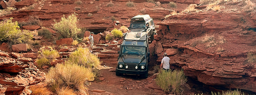
The Technical Core of Lockhart Basin
As we moved north, the trail quickly shifted from simple to serious. The ledges became taller, the washouts deeper, and the exposure steeper.

Lockhart Basin’s rock formations — mostly Wingate Sandstone, layered with Kayenta and Chinle formations — create natural staircases and terraces. Over millions of years, erosion carved these benches into sharp, uneven steps that now form the trail itself.
Progress was slow. Each obstacle required precision: choosing the right line, crawling gently over edges, and spotting for one another through the tighter turns. A few off-camber sections leaned heavily toward the canyon side — enough to remind us why this route carries an “expert” label.
Even with the difficulty, it was incredible terrain. The views west toward Canyonlands were wide open, the air clear and quiet. Every stop offered a new angle on the landscape that felt vast and ancient.
Reading the Land
One of the striking things about Lockhart Basin is how clearly it tells the story of its own geology. The red cliffs we climbed through were once massive dunes, deposited in the Late Triassic and Early Jurassic periods.
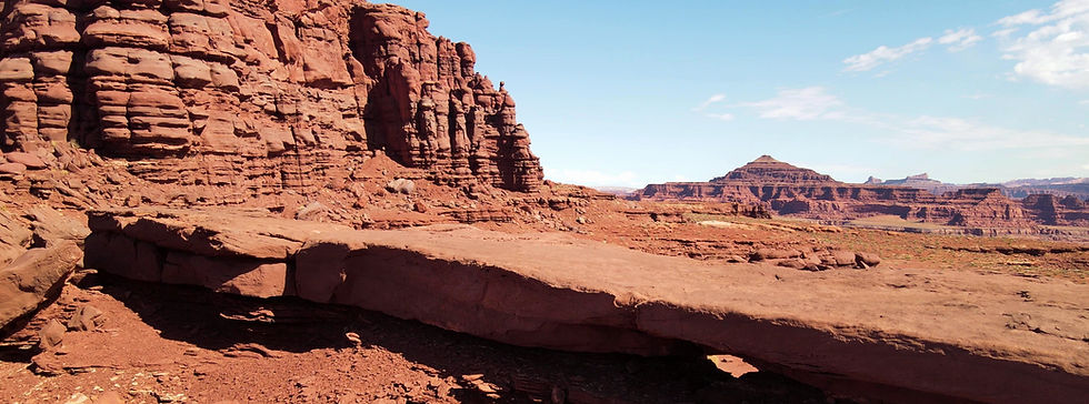
Over time, these dunes compacted into sandstone, and later erosion by wind and water cut deep channels through the rock. Every bend in the route exposed new layers and color shifts — a living cross-section of the Colorado Plateau.

It’s one of the few trails where the drive itself becomes a lesson in natural history.
Chicken Corners
Eventually, the tight ledges gave way to wider, more open trail — and soon after, we reached Chicken Corners, a famous overlook along the rim of the Colorado River.
The name comes from early offroad travelers who would ask their passengers — “the chickens” — to get out and walk this stretch rather than ride along the narrow shelf road. Even today, the drop is dramatic.
The view was worth every mile. From the edge, the Colorado River curved through Canyonlands hundreds of feet below, its green surface cutting a sharp line between sheer red cliffs. Across the river, the Needles District shimmered in the afternoon light.

Hurrah Pass and the Descent to Moab
From Chicken Corners, the route turned east and began the climb toward Hurrah Pass — a winding ascent of red dirt and slickrock that marked the final push toward civilization.
Compared to the basin, Hurrah Pass felt easygoing. The road was smoother and more defined, though still steep in places. As we climbed, the view back toward the basin expanded until it seemed endless — layer after layer of mesas and canyons fading into blue haze.
At the top, the world opened completely. Below us stretched the Colorado River Valley, with Moab tucked beneath the cliffs to the northeast. It was the first real sign of civilization in days.
The descent into town was quiet. The trail wound through red canyons, eventually turning to graded road and then pavement. After four days of dirt, the sound of tires on asphalt felt almost foreign.
Arrival in Moab
By late afternoon, we rolled into Moab, rigs coated in dust, tired but content. After more than 180 miles of trail, we had completed Segment 2 of the Utah BDR — from the forests of the Abajos to the depths of Lockhart Basin, and finally back to pavement.

For us, this day captured the full essence of the Utah BDR: rugged terrain, quiet solitude, and the constant balance between challenge and beauty.
Route Overview
Section | Distance | Terrain | Notable Features |
Lockhart Basin Escarpment → Technical Section | ~20 miles | Slickrock, ledges, shelves | Most challenging 4x4 section on Utah BDR |
Technical Section → Chicken Corners | ~10 miles | Canyon benches, steep exposure | Views over Colorado River |
Chicken Corners → Hurrah Pass | ~8 miles | Red dirt, slickrock | Classic canyon driving, wide views |
Hurrah Pass → Moab | ~12 miles | Graded road | Smooth descent into Moab Valley |
Trail Difficulty
Lockhart Basin (North): Difficult – ledges, off-camber climbs, exposure
Chicken Corners: Moderate – narrow shelf road with dramatic drop-offs
Hurrah Pass: Easy to Moderate – graded dirt and slickrock climb
Vehicle Requirements: High-clearance 4x4 with low range; experienced ADV riders only
Plan Your Own Ride
Utah Backcountry Discovery Route – Official Site: Official route information, GPX tracks, and trip planning resources.
Trails Offroad – Lockhart Basin Guide: Detailed difficulty ratings, route descriptions, and user reports. Use TrailsOffroad with our 'Discount Code'.
Trails Offroad – Chicken Corners & Hurrah Pass: Trail data for the final stretch into Moab.
Moab BLM Recreation Info: Camping and public land regulations for the Moab area.
Read & Watch the Full UtahTrip
This post is part of Hardline HQ’s multi-day journey across the Utah Backcountry Discovery Route — from the mesas of Monument Valley to the alpine passes of the La Sals and Book Cliffs. Each article captures the story behind the drive, but the full experience lives on video.👉 Watch the entire Utah BDR series on YouTube: Hardline HQ Channel


Comments