
Nelson Ghost Town & Mohave Road
- Jens Brown

- Apr 7, 2024
- 6 min read
Updated: Oct 1, 2025
In March 2024 I linked up with the Offroad Overland Camping crew for a three-night overlanding trip across the southern Nevada desert. Ron Channels led the run, joined by Rob, Mark, Mimi, James, another Mark, newcomers Bob and Carla, and me making the drive in from Phoenix. The plan was to explore Nelson Ghost Town, tackle Copper Cache and the Nelson Loop trails, and finish out on the Mojave Road with a camp in the New York Mountains.
Day 1: Searchlight to Morning Star Cove
We met in Searchlight, Nevada, a dusty outpost on US-95 that served as our rally point. Most of the group had come in from Southern California, while I rolled up from Arizona. After a quick briefing at the Chevron, we aired down and headed west toward Lake Mead.

The first leg took us down Montana Wash Road, a gravel trail inside Lake Mead National Recreation Area. It’s an easy track that winds through a dry wash, with coarse sand, shallow ruts, and the occasional washboard. The views opened quickly: wide desert, glimpses of Fire Mountain, and eventually the blue water of the Colorado River.
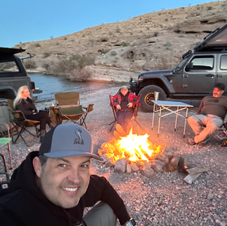
By late afternoon we reached Morning Star Cove, a broad bay tucked against the cliffs. The cove offered two large dispersed campsites right along the shoreline. We set up camp with rigs lined in the sand, the lake at our backs, and desert hills glowing red in the evening light.


There are no amenities here — you pack in everything and pack out everything, waste included — but that’s part of the appeal. If you had friends meeting by boat, this would be the perfect place to link up.

That night, the air coming off the river dropped the temperature fast. We pulled chairs close to the fire and settled into the rhythm of the trip: stories, gear talk, and the quiet of the desert once the flames died down.
Day 2: Nelson Ghost Town & Copper Cache Canyon
The next morning we backtracked up Aztec Wash and stopped at Nelson Ghost Town. Once tied to the Techatticup Mine, Nelson had a reputation in the 1800s for violence and lawlessness. Today it’s part relic, part outdoor museum — weathered storefronts, rusted vehicles, and mining equipment scattered across the canyon. We parked among the relics and had lunch surrounded by the desert’s boomtown history.


From there, we pointed the rigs into Copper Cache Canyon, one of the region’s most popular rock crawling trails. Located just minutes from town, the trail begins in a nondescript wash but quickly turns into a technical route through a narrow slot canyon. Rock ledges, big boulders, and tight squeezes kept the group focused, with occasional remnants of an old mine tucked into the canyon walls.
The obstacles demanded careful driving and spotting. It wasn’t extreme to the point of carnage, but it was technical enough that everyone respected the terrain. Linking Copper Cache with Rollercoaster (steep climbs and descents) and Goldmine (winding terrain through dig sites) made for a memorable afternoon of driving.
It was on one of these climbs, near Rollercoaster, that a TJ pulling a trailer stalled out. The incline was too much, and momentum gave out. What could have been frustration instead turned into one of the trip’s highlights — a group recovery effort. Straps, spotters, and steady throttle got the rig and trailer over the obstacle. It was problem solving in real time, a reminder that recovery is as much about teamwork as it is about gear. For all of us, it was camaraderie at its best and a chance to exercise the capability of our Jeeps beyond just trail driving.
By late afternoon, we had cleared the loop and made our way west on the Mojave Trail setting up camp at dusk. The desert cooled quickly, and another night fell around the fire.

Day 3: On the Mojave Trail
Day three gave us time to explore smaller mines, abandoned cabins, and scattered relics along the Mohave Trail. A Route with Deep Roots.
The Mojave Trail stretches ~150 miles from the Colorado River near Laughlin to Barstow, California.
7,000 years ago: Mojave tribes used the route to trade shells, salt, obsidian, and food between the river and the Pacific.
1770s: Father Francisco Garcés crossed sections of it with Juan Bautista de Anza’s expeditions, becoming the first European to meet the Mojave Indians.
1826: Mountain man Jedediah Smith became the first American to travel the route. By 1829, Mexican traders had tied it into the Old Spanish Trail.
1849 Gold Rush: Thousands of settlers moved west. Rock Springs became a critical water point, named by Army engineer Amiel Whipple during his 1854 survey.
1858 Mojave War: Conflict with tribes pushed the U.S. Army to seize control. Forts like Fort Piute, Camp Rock Spring, and Fort Mohave secured water sources and guarded the trail until the 1870s.
1900s: Mining and ranching followed. Gunfights over water rights at Rock Spring continued into the 1920s.
1980s: Rediscovered and popularized by historian Dennis Casebier, whose Mojave Road Guide remains the standard reference today.
In 1866, J.F. Rusling described his crossing:
“The country, as a whole, seemed a vast volcanic desert — of mountains, canyons, and mesas — and what it was ever made for, except to excite wonder and astonishment, is a mystery to the passing traveler… Water was found only at distances of ten and twenty miles apart.”
Driving it today, little has changed. Our run took us into the New York Mountains, where we made our final camp. The trail was a mix of sandy washes, rocky climbs, and wide-open flats where dust hung behind the rigs.


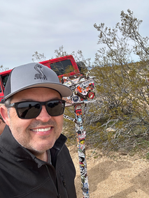


Along the way we stopped at lava tubes, climbing down into volcanic chambers where sunlight pierced through openings in the rock, and wound through forests of Joshua trees unique to this desert. Scattered cabins and mine sites reminded us how people once tried — and mostly failed — to settle in this unforgiving terrain.
Lessons Learned
The driving and history were memorable, but for me, the biggest lesson came at camp. I had packed too much — bulky totes, a Gazelle tent that was comfortable but too large for daily setup and breakdown, and a cot that took up more space than it was worth. One particularly cold night drove the point home: efficiency matters. Next time I’ll pare down supplies and get more creative about staying warm without hauling unnecessary gear.
Wrap Up / Takeaway
By the time we rolled out on day four, we had covered ghost towns, slot canyons, lava tubes, and the Mojave Trail. We had camped on the edge of Lake Mead, recovered a struggling rig on a hill climb, and shared firelight in the New York Mountains.

The Mojave doesn’t smooth its edges — it’s raw desert, open distance, and scattered relics of the people who came before. With a solid group and a few lessons learned, it made for a run that balanced history, tough trails, and nights under desert skies.
Key Stops & History
Montana Wash Road — Gravel track through Lake Mead NRA with views of Fire Mountain, ending at Morning Star Cove.
Morning Star Cove (Lake Mead) — First night’s camp on a broad bay along the Colorado River.
Nelson Ghost Town & Techatticup Mine — Once one of Nevada’s most violent boomtowns; now a preserved ghost town.
Copper Cache Canyon — A slot canyon with ledges, boulders, and an old mine site; one of the region’s premier rock crawling trails.
Rollercoaster & Goldmine Trails — Steep climbs, loose terrain, and mining relics linking with Copper Cache for a full loop.
Mojave Trail — 150-mile historic trade route used by tribes, Spanish explorers, settlers, and the U.S. Army. Rediscovered in the 1980s by Dennis Casebier.
Lava Tubes — Volcanic chambers lit by beams of sunlight.
Joshua Tree Desert Trails — Forests of Joshua trees unique to this desert region.
Abandoned Cabins & Mines — Remains of mining and ranching settlements.
New York Mountains — Rugged backdrop for the final camp, with cold desert nights and sweeping views.
Trail Notes
Length: About 150+ miles total across four days, including the Mojave Trail’s ~150-mile stretch. Searchlight, MV to Montana Wash Road, then Aztec Wash Road to Copper Cache Canyon. From Nelson Ghost Town, take the Nelson Roller Coaster to Mojave Road.
TrailsOffroad 'Discount Code'
Difficulty: Moderate to challenging. Slot canyons, rocky ledges, steep climbs, sandy stretches, and washboard flats. Spotting often needed.
Best Season: Fall through spring. Summer is dangerous; winter nights can be freezing.
Time Needed: Three to four days to cover Nelson, Copper Cache, the Loop Trails, and the Mojave Trail with time for camp setup each night.
Gear Lessons Learned: Downsizing is critical for multi-day trips. Totes, oversized tents, and bulky cots slow down camp moves. Pack light, pack smart.
Driving the Mojave Road Today
Overview: The Mojave Road runs ~150 miles east–west from the Colorado River to Barstow, mostly inside Mojave National Preserve. Allow three days to drive its full length.
Vehicle Requirements: High-clearance 4x4 is strongly recommended. The road is not maintained — expect deep sand, ruts, rocky climbs, and seasonal washouts.
Water & Hazards: Historic water sources are still spaced 10–20 miles apart. Modern travelers must carry ample water. Hazards include flooding of Soda Dry Lake, monsoon washouts, and occasional winter snow or ice.
Camping: Dispersed camping is permitted along the route on a first-come basis. No fees or reservations.
Navigation: The trail is marked by cairns, but navigation can be tricky. The Mojave Road Guide by Dennis Casebier is still the best mile-by-mile resource.
Best Time to Go: Fall through spring. Summer temps exceed 110°F and are unsafe.


Comments