
A Descent Through Utah’s Canyon Country
- Jens Brown

- Oct 25, 2025
- 5 min read
Updated: Dec 2, 2025
Utah BDR Day 5: From Porcupine Rim to the Colorado River
Part of the Utah BDR Series
Our Utah Backcountry Discovery Route adventure had already taken us from Monument Valley’s red sandstone spires to the high forests of the Abajo Mountains, through the small town of Monticello, and into the canyonlands beyond.
Day 4 carried us through the northern half of Lockhart Basin — the most technical and demanding stretch of the entire route — before crossing Chicken Corners and Hurrah Pass, finally rolling into Moab after four days on the trail. If you missed that section, you can read it here:📍 Utah BDR Day 3 & 4 Lockhart Basin and Moab
The following morning, we explored Hell’s Revenge, Moab’s most famous slickrock playground, before heading east to begin the second half of Day 5 — a full transition from the sandstone bowls of Moab to the river canyons and mesas beyond.
If you missed that section, you can read it here:📍 Utah BDR Day 5 (Morning): Hell’s Revenge Trail – Moab, Utah
A Transition from Slickrock to Rim Country
By late morning, we had finished Hell’s Revenge and climbed back into the Sand Flats Recreation Area. The Utah BDR is full of contrasts, and this part of the route offered one of the biggest — from slow, technical slickrock crawling to open mesa roads with views that stretched for miles.

The road to Porcupine Rim wound steadily upward through pinyon and juniper, climbing toward the edge of the high mesa. The drive wasn’t difficult, but it was steep in places, and the elevation gain was quick — from roughly 4,000 feet in Moab to nearly 9,000 at the rim.
From the top, the view opened completely. Castle Valley spread out below, framed by the La Sal Mountains to the southeast and the canyons of the Colorado River far off to the west. The rim had long served as a vantage point for travelers and surveyors, and standing there, it was easy to see why.
The Kokopelli Trail
From the rim, the route turned east onto the Kokopelli Trail — a 142-mile corridor that connects Moab, Utah, with Fruita, Colorado. It’s named after the flute-playing figure found in rock art across the Southwest, a symbol of travel, trade, and storytelling.

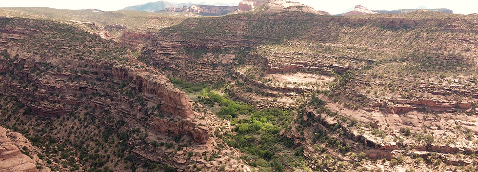
This section of the trail was rough and rutted in places, with scattered sandstone shelves
that kept speeds low. The surface shifted constantly — sand, packed clay, and stone. The driving wasn’t technical, but it was engaging, with constant movement and new views at every bend.
Vegetation reflected the transition in elevation. Rabbitbrush and bitterbrush gave way to Gambel oak, mountain mahogany, and patches of low scrub oak — many of them just beginning to turn bronze and red with the changing season. The higher air carried a trace of cool mountain wind, a reminder that fall wasn’t far off.
Bull Canyon and the Dinosaur Tracks
A short spur off the main route led to Bull Canyon, where a patch of sandstone held a set of fossilized dinosaur tracks. The three-toed prints, pressed into the surface more than 150 million years ago, were remarkably sharp — likely left by a small theropod when this area was a muddy lakeshore.

The rock belonged to the Entrada Formation, the same sandstone that shapes much of the slickrock around Moab. It’s a small stop, but one that adds perspective. The day’s trail had taken us across millions of years of geologic history — and these footprints made that connection tangible.
The Descent Toward Onion Creek
From Bull Canyon, the trail began a long descent toward Onion Creek — nearly two hours of downhill travel. The route wasn’t difficult, but it was rough. Ledges, washouts, and rocky sections kept the suspension moving constantly, demanding a steady hand and patience rather than skill.

Halfway down, a mountain biker we had passed earlier in the day came flying by, smiling as she carved through the descent at twice our speed. Gravity was on her side, and we couldn’t help but laugh as she disappeared down the slope.
The lower we dropped, the wider the views became. Fisher Valley opened ahead, and the red walls of Onion Creek Canyon began to close in. Light shifted with every curve — bright sun to shade, gold to crimson — until the road finally met the water.
Through Onion Creek Canyon
Onion Creek was one of the most enjoyable drives of the entire Utah BDR. The road crossed the creek over twenty times, winding through a narrow canyon with high, colorful walls. The crossings were shallow but constant, each one adding a little rhythm to the drive.
The canyon’s striped walls came from the Cutler Formation, a series of ancient sediments tilted and folded by underlying salt deposits of the Paradox Basin. The result was a vivid mix of reds, oranges, and purples — layers that seemed to twist and ripple as the canyon turned.
This corridor had been used for generations. Ranchers once drove cattle through here to reach the river at Dewey. Today, it carried overlanders and locals alike — still serving its purpose as a natural passage through otherwise rugged country.

Every corner revealed something new — color, texture, or light. The temperature dropped each time we entered shadow and rose again as soon as the sun reappeared. It was the kind of section that made the slower pace worthwhile.
Following the Colorado to Dewey Bridge
The canyon opened abruptly into the river corridor, and the route joined Highway 128. From there, it was about twenty minutes north to Dewey Bridge — an easy, scenic drive with the Colorado River on our left and sheer cliffs rising on our right. Cottonwoods lined the river, and late light turned the reeds along the banks to gold.
We reached the bridge just before sunset. Built in 1916, it was once the longest suspension bridge west of the Mississippi, carrying wagons and early automobiles across the Colorado. A fire in 2008 destroyed the deck, but the towers and cables still stand, marking the confluence of the Dolores River and the Colorado River.
We set up camp just downstream, where the two rivers meet. After starting the day near 9,000 feet, we were now at about 4,200 — back in the desert, surrounded by canyon walls and the steady sound of the river.
Evening settled quickly. Once the tailgates dropped and camp chairs came out, the pace slowed. The light faded, the river glowed red, and the day ended the way a long day should — quiet, unhurried, and complete.
Next Up
The next leg would take us north toward the Book Cliffs and the ghost town of Sego, closing out our journey along the Utah Backcountry Discovery Route.


Comments