
Backway to Crown King Trip Report
- Jens Brown

- Dec 9, 2025
- 5 min read
Backway to Crown King: Old Mines, Fall Weather & a Trailside Roll-over
Fall settles into central Arizona slowly, but once it arrives you feel it right away. The air around Lake Pleasant lifts a little, the horizon sharpens, and the desert seems to loosen its shoulders after months of heat. We rolled out along Castle Hot Springs Road that morning, easing through open flats where saguaros spread themselves at comfortable distances and the washes hid mesquite, palo verde, and the occasional oak.
It is a familiar road, although it always has a few details you only catch when the light is right.

China Dam: A Stone Wall Against Time
China Dam was the first stop. It sits quietly in a small canyon, just a short detour from the main route, and it always feels older than the landscape around it. Chinese laborers built it more than a century and a half ago, shaping stone by hand to trap enough runoff for livestock and early mining work. The structure is not large, but it is stubborn. Flash floods have not pulled it apart, and dry seasons have not cracked it open.
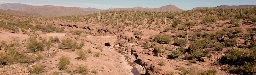
The stones have held longer than the towns that once depended on it.
From there the day felt like it was slipping into a steady rhythm. Simple roads, a gentle climb, and a bit of history tucked into the quiet corners of the desert.

Tule Homestead: A Glimpse of Life in the Foothills
The Tule Homestead came next. Nothing dramatic, just the remains of a place where families tried to make a living in the foothills. A few walls, some stonework, the outline of a yard. You can picture the rhythm of it. Cattle wandering the draws, someone hauling water, someone else watching the sky to guess what the season would bring. Life out here did not leave many footprints, but the ones that remain feel honest.

Dropping back down to Castle Hot Springs Road gives you a better sense of how the land works. The washes steer you whether you want to follow them or not. The ridges rise where they always have. It is about eight miles back to the main route. Not far, but slow enough to get you thinking about how the day may unfold.
Cow Creek Road: Rising Toward Old Mining Country
Once we picked up Cow Creek Road, the climb into the Bradshaws began in earnest. The first part is not complicated. Just elevation, one gentle grade after another, and the gradual shift from desert plants to scrub oak and manzanita. A little farther up we passed an active mining claim. Modern equipment tucked into an old landscape. It is a reminder that the mountains still attract people who are willing to take a chance, the same way miners did more than a hundred years ago.

The geology here explains why the roads exist. Volcanic and intrusive formations pushed upward and fractured, creating channels where gold, silver, and copper settled into veins. Most of the mining sites were small, usually just a cabin, a short shaft, a couple of pack animals, and a road narrow enough that a wagon could barely squeeze through. You catch glimpses of their work in tailings piles and the occasional bit of rusted pipe. You have to slow down to see it. At speed it becomes texture.

The Upper Trail: Where the Drive Turns Technical
The upper part of the trail is where things change. Pines start showing up, and the road works its way into granite shelves and deeper ruts. The Backway is known for this transition. It is easygoing for most of its length, and then suddenly it asks for more attention. That is where I found the couple in the rental Rubicon, working their way toward the final obstacles.
We talked for a few minutes. They were taking their time and doing everything right, so I told them I would wait near the last set of ledges in case they needed a hand. A rental Jeep is usually not built for this section, with no lift, mild tires, and not much protection beneath.
I did not get up the Waterfall on my first try either. A few adjustments, a couple of hits on the driveshaft, and eventually the right line opened up. When the couple took their turn, the Jeep hung up on the center skid. We tried the usual options, rock stacking, a few small shifts, and even a two-rope pull, but the obstacle did not offer much margin. One rear tire climbed onto a rock shelf, the opposite one dropped into a shallow pocket, and the Jeep leaned just a little too far.

Then the weight shifted, almost in slow motion. Maybe the steering input was just a touch too much, or maybe the breakover angle was sharper than it looked. Whatever the cause, the Rubicon tipped onto its side and settled against the uphill bank of the shelf road. No one was hurt. Everyone stayed calm. The day, however, changed immediately.
Aftermath: A Different Ending to the Day
We could not recover it safely with the equipment we had. The hardtop had shattered, so we helped gather their luggage and loaded everything into my vehicle. From a higher part of the trail the rollover looked like it could have gone much worse, which added a quiet weight to the drive out. Other groups on side-by-sides paused on the trail, deciding how to navigate the blockage. Cell service was marginal, but just enough for the calls that mattered.
We reached Crown King after dark and found a warm welcome at the café. A quick meal, a few calls to the Sheriff’s office and the rental company, and the couple began figuring out the rest of their trip. Eventually we drove back to the Phoenix airport so they could get another car and continue on. The Rubicon stayed behind in the Bradshaw Mountains, waiting for a recovery team in the morning.

Not the ending any of us expected, but a good reminder that even on familiar trails the mountains still have their own way of keeping things interesting.
Trail Guide

Hardline readers looking for detailed GPS tracks, current conditions, and obstacle walkthroughs can check out the official TrailsOffroad write-up for this route:
👉 TrailsOffroad – Backway to Crown King - Detailed technical guide, difficulty ratings, and current conditions.
👉 TrailsOffroad – China Dam / Tule Creek Homestead - Detailed technical guide, difficulty ratings, and current conditions.
Use TrailsOffroad with our 'Discount Code' to save on a TrailsOffroad membership and unlock thousands of trail guides across the Southwest and beyond.
Route Overview
The Backway to Crown King begins north of Lake Pleasant and climbs through desert flats, foothill drainages, and the rugged terrain of the Bradshaw Mountains. The route combines historic corridors, old mining roads, and a few technical obstacles near the top. Most of the drive is moderate, although conditions vary widely with weather and traffic.
Distance: ~25 miles (depending on approach)
Time: 4 to 6 hours, allowing for stops
Difficulty: Moderate with a few difficult sections near the summit
Highest Elevation: ~6,000 feet in Crown King
Vehicle Requirements: High-clearance 4x4 with low range


Comments