
Rim-to-Rim Grand Canyon Hike in One Day | Hardline HQ
- Jens Brown

- Oct 1, 2025
- 5 min read
Updated: Oct 9, 2025
What is the Rim-to-Rim Hike?
The Rim-to-Rim (R2R) hike is one of the most iconic challenges in the national park system. It runs from the North Rim (8,200 ft) to the South Rim (7,200 ft) of the Grand Canyon, about 24 miles in total. Along the way, hikers descend nearly 6,000 feet to the Colorado River before climbing back up roughly 4,800 feet.
Only a small fraction of the canyon’s millions of visitors attempt it, and fewer still complete it in a single day. Preparation, fitness, and strategy are non-negotiable.
Training and Preparation Tips
What’s Recommended
Training: Long hikes of 10–15 miles with elevation gain, ideally in back-to-back days.
Hydration: 5–6 liters of water capacity. Electrolyte mix and salt supplements to prevent cramping.
Food: Eat every hour. Salty, carb-heavy snacks work best.
Gear: Trekking poles, breathable clothes, sun protection, headlamp.
Timing: Start before dawn to cross the inner canyon before it becomes a furnace.
What I Did
For months, I trained on desert trails around Phoenix and Scottsdale, hiking 10–15 miles nearly every week. On the hike itself I carried six liters of water (four plain, two with electrolytes), along with SaltStick supplements and snacks like trail mix and jerky. This system worked — I finished tired but upright.
Logistics: Shuttle, Lodging & Planning Ahead
I staged at the South Rim and booked the Trans-Canyon Shuttle in advance. Seats sell out quickly. The afternoon shuttle leaves 1:30 PM from Bright Angel Lodge and reaches the North Rim by dinner.

The route is almost a tour in itself:
Cameron, AZ – A trading post town on the Little Colorado River, known for Native crafts.
Cliff Dwellers, Marble Canyon (4:30 PM) – Where the Colorado River begins to carve Marble Canyon, framed by the Vermilion Cliffs.
Jacob Lake Inn (5:15 PM) – At 8,000 feet on the Kaibab Plateau, surrounded by ponderosa pines.
From there the road climbs through Kaibab National Forest, arriving at the North Kaibab Trailhead in the evening.
I stayed at the North Rim Lodge, perched at the canyon’s edge. On the shuttle I met a brother and sister also hiking Rim-to-Rim, we ended up having a great dinner of steak, fresh bread and vegetables.

We traded preparation stories while the sun set over the cliffs. Weeks later, the lodge was destroyed in a forest fire — making that meal feel like a piece of history.
North Kaibab Descent: History and Highlights
North Rim Lodge (8,200 ft, mile 0) Trail at 2:00 AM, with headlamp cutting through pine forest. The cool air made for fast miles in silence.
Supai Tunnel (6,800 ft, mile 1.7) A Civilian Conservation Corps project from the 1930s, blasted through the limestone. Past this, the trail leaves the forest and begins dropping sharply into canyon layers.
Roaring Springs (5,200 ft, mile 4.7) A torrent of water bursts from the Redwall cliffs, forming Bright Angel Creek. It’s the source of the park’s water pipeline — and a reminder that life here has always hinged on water.
Cottonwood Campground (4,080 ft, mile 6.8) A flat, open stretch along Bright Angel Creek. Archeological sites nearby show prehistoric farming and storage. For me, it was a quick snack and water break.
The Box (3,800 ft, mile 11) The canyon narrows into billion-year-old Vishnu schist. In June, this section is notorious for extreme heat — often above 120°F. I cleared it by 8:00 AM, while shadows still lingered.
Phantom Ranch (2,480 ft, mile 14) Arrived at 8:30 AM. Phantom Ranch was built in 1922 by architect Mary Colter, but the site has been used by Native peoples for thousands of years. I soaked clothes in Bright Angel Creek, ate, and refilled six liters of water. Departed just before 10:00 AM.
Phantom Ranch and Crossing the Colorado
Black Bridge (2,400 ft, mile 14.2) Crossing the Colorado is a psychological halfway point. The Black Bridge, completed in 1928, was built by hauling steel cables down the canyon by mule.


Normally, hikers can connect to Bright Angel via the River Trail, but it was closed for waterline work. The detour — 4+ miles of shadeless Tonto Trail — was unsafe in June heat. I committed to the South Kaibab Trail: shorter, far steeper, no water until the rim.
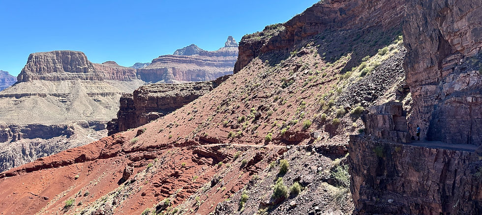
South Kaibab Ascent: The Final Climb
Tipoff (4,000 ft, mile 16.5) Here the climb began in earnest. The river disappeared below as switchbacks cut into the cliffs. Heat eased slightly with altitude, but the grind was relentless.
Skeleton Point (5,200 ft, mile 17.5) A sweeping overlook of the inner canyon. It takes its name from mule freight accidents of the past — stark reminder of the trail’s difficulty. My pace slowed, relying on saltsticks and steady sips of water.
Cedar Ridge (6,500 ft, mile 19.5) A broad plateau with open views. Fresh-faced day-hikers started to appear here, full of energy. For me, it was a marker of progress but also a contrast: their hike was beginning, mine was almost spent.
Ooh Aah Point (6,700 ft, mile 20.5) Only a mile from the rim. Crowded with families posing for photos. I shuffled through, exhausted but encouraged — the finish line finally in sight.
South Rim (7,200 ft, mile 21) Topped out at 3:45 PM. My last sip of water was minutes earlier. Total time: 13 hours, 45 minutes.

Checked into my hotel, showered, and staggered to the bar. I ordered a dozen wings, a pizza, and a double Jack and Diet. I managed the drink, two wings, and one slice of pizza before collapsing. Ten hours later, I woke up with the pizza box still on the bed.
Reflections: Lessons from Rim-to-Rim
The Rim-to-Rim is a journey through time. The descent crosses forests into billion-year-old schist. Springs like Roaring Springs sustained Native peoples, while tunnels like Supai mark the work of Depression-era crews.
Training, water management, salts, and food made all the difference. Without them, the hike would have ended differently. In the end, the canyon isn’t conquered — it’s endured.
Trail Notes & Quick Reference
Things to Avoid & How to Prepare
Avoid midday exposure. Start before dawn.
Don’t under-carry water. Pipelines can fail. Six liters minimum.
Avoid detours in heat. Bright Angel via Tonto is unsafe in summer.
Don’t overpack. Every pound matters.
Do train. Long hikes with climbs are essential.
Do fuel regularly. Snacks and electrolytes keep you upright.
Trail Notes
Distance: ~24 miles
Descent: ~6,000 ft (North Kaibab)
Ascent: ~4,800 ft (South Kaibab)
Time: 12–16 hours typical; mine took 13h 45m
Season: Spring or fall ideal. June only with extreme caution.
Logistics: Shuttle ~4 hours. North Rim open May–October; South Rim year-round.


Comments